This morning I am prepping for the drive back to Phoenix. That is Mapquesting the route (it should be I-10 all the way, but I-10 gets confused around Houston in Texas), paying this month's bills, and totaling up the mileage from the ride.
Mileage total for the Ride of a Lifetime stands at 2719.4 . That includes our little detours, my wrong turns, and all the rest. I still can't get over what a great ride it has been, and can't wait to start planning the next one.
I will run up another post later reference the return trip and some of the other stuff that happened on this trip. But for now, got to pay the bills and get ready to go home.
We left St. Augustine at 0700 Phoenix time (1000 local time) on Saturday the 2nd. I had told father that I planned on driving straight through from Florida to Arizona, and that he might be more comfortable taking a flight back. I even checked the flights out of Jacksonville and found him a flight - 6 hrs, home (in Phoenix) by 3PM the second, under $200, and an extra day to drive back to Colorado, because he is very worried about getting back to vote. He decided that he would rather ride back with us - 15 to 17 hours in the car, no stopping, no meals, just snacks and drinks in the car.
But he decided that he wanted to ride back with us. This is the same old fart that complained to me for 5 weeks because he had to sit in the car driving for us and it stiffened up his knees too much. So we loaded up the car and took off for the return. I stopped every 2 to three hours for gas breaks or potty stops. So father, playing the martyr and throwing his best guilt trip at me, rode in the front passenger seat and refused to eat or drink the whole trip. He also refused to fasten his seatbelt and wouldn't recline his seat to nap. Acting just like a spoiled little baby, he finally about 3 AM, demanded that we had to stop and sleep for a few hours. I told him that we had discussed this, we weren't stopping, and I had offered to let him take a plane. He was delivered to his home in Scottsdale at 2:30PM and we said good-bye. He could have been there almost 24 hours earlier if he wasn't being a pain again.
Friday, November 2, 2012
Thursday, November 1, 2012
Day 40 (Melrose to St.Augustine, FL)
Where's Waldo?

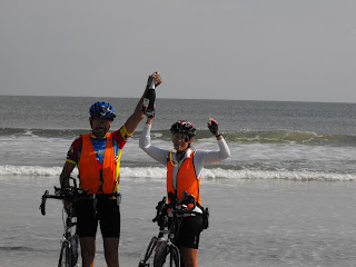
That's the title I wanted to use for today's post, after spending last night in Waldo, Florida. But it really seems like a lame title when today, WE FINISHED THE RIDE! We rolled onto St. Augustine beach just before noon this morning, November 1st, a day before my 60th birthday. The feeling was so good as we rolled onto the beach and started walking toward the Atlantic Ocean for our pictures, that Karen started to cry a little, and I was even a little choked up. The other side of that coin is that we are both willing to get on our bikes and ride back to Phoenix.
Yesterday we ended our ride in Melrose after I realized that we had ridden 10 extra miles due to my mistake. Father took us to Waldo, the closest town that had a decent motel (according to the locals). In fact the other local establishments were referred to as "roach motels". So we stayed at the Comfort Inn in Waldo, ate Mexican food one more time, and retired.
The day started out cool, in the mid 50's, and overcast. Because it was in the 50's I was just wearing my regular short sleeved jersey (my birthday present from Karen) and bike shorts. It took a few miles to get warmed up, but when we did the excitement of finishing took over and we really started spinning, running almost 18mph average for the 56 miles.
I modified the ride again, taking straight roads instead of the ACA paths (thanks Dennis for the reminders). It cut off a few miles and was still a nice, pretty ride. For anyone else coming this way, we came in on 100 to 206, then straight to the beaches. The shoulders are very nice, except where they lead up to bridges. There they narrow and the quarter mile lead in to the bridge has speed bumps that will loosen your eyeballs.
We got to Crescent Beach and rode north on A1A to the first St.Augustine Beach sign we saw. There we took photos, and turned down the road to the beach. The pure white sand of the beach and the smooth Atlantic Ocean were a very welcome sight, and gave no indication that hurricane Sandy had recently passed by. Karen and I took photos, drank our bottle of celebratory Champagne, and enjoyed being done. We also talked to one off the local Beach Patrol Police officers who is wanting to do a similar tour. He was impressed and very inquisitive about bicycle touring, so we were glad to share some of our info and adventures.


 We are done, and we would do it again in a heartbeat. Thanks for all the interest, comments, and for keeping up with our adventure. Now it's back to Phoenix.
Map and Numbers:
http://connect.garmin.com/activity/239213526#.UJLbRC5Fxa8.blogger

That's the title I wanted to use for today's post, after spending last night in Waldo, Florida. But it really seems like a lame title when today, WE FINISHED THE RIDE! We rolled onto St. Augustine beach just before noon this morning, November 1st, a day before my 60th birthday. The feeling was so good as we rolled onto the beach and started walking toward the Atlantic Ocean for our pictures, that Karen started to cry a little, and I was even a little choked up. The other side of that coin is that we are both willing to get on our bikes and ride back to Phoenix.
Yesterday we ended our ride in Melrose after I realized that we had ridden 10 extra miles due to my mistake. Father took us to Waldo, the closest town that had a decent motel (according to the locals). In fact the other local establishments were referred to as "roach motels". So we stayed at the Comfort Inn in Waldo, ate Mexican food one more time, and retired.
The day started out cool, in the mid 50's, and overcast. Because it was in the 50's I was just wearing my regular short sleeved jersey (my birthday present from Karen) and bike shorts. It took a few miles to get warmed up, but when we did the excitement of finishing took over and we really started spinning, running almost 18mph average for the 56 miles.
I modified the ride again, taking straight roads instead of the ACA paths (thanks Dennis for the reminders). It cut off a few miles and was still a nice, pretty ride. For anyone else coming this way, we came in on 100 to 206, then straight to the beaches. The shoulders are very nice, except where they lead up to bridges. There they narrow and the quarter mile lead in to the bridge has speed bumps that will loosen your eyeballs.
We got to Crescent Beach and rode north on A1A to the first St.Augustine Beach sign we saw. There we took photos, and turned down the road to the beach. The pure white sand of the beach and the smooth Atlantic Ocean were a very welcome sight, and gave no indication that hurricane Sandy had recently passed by. Karen and I took photos, drank our bottle of celebratory Champagne, and enjoyed being done. We also talked to one off the local Beach Patrol Police officers who is wanting to do a similar tour. He was impressed and very inquisitive about bicycle touring, so we were glad to share some of our info and adventures.


Map and Numbers:
http://connect.garmin.com/activity/239213526#.UJLbRC5Fxa8.blogger
Wednesday, October 31, 2012
Day 39 (White Springs to Melrose, FL)
Today we started at White Springs, a small sort of town near the intersection of I-10 and I-75. We left from there following the ACA route south on 137. The morning was cold again (42 degrees) and we enjoyed a nice traffic free ride. Passing through Wellborn, we saw a great example of southern car customizing.

We saw several deer this morning all of them walking into or from the tree farms. I still don't know what kind of trees they farm or why, but the farms are interesting, going on for acres or miles.

Another of the cash crops down here are the "Miniature Horses". There were several ranches raising and advertising the miniatures. I took a photo of one of the horses, that could only have been about three feet tall.

Karen and I have come to the conclusion that of all of the states we have ridden through, Florida's drivers are the worst and most discourteous. Today we were yelled at, honked at, and nearly forced off the road several times. Even when the drivers have room to move over, they frequently will move closer to the bicyclist in a distinct effort to try moving them off the paved shoulder. Karen and I have been aware of this almost since we crossed into the state and we ride VERY defensively. We hate being around these drivers. While many of the motorists are OK, there is an extremely high percentage of what the good ole boys in Mississippi call "dumbasses".
After we got to Gainsville today, we had only ridden about 65 miles. Karen and I decided to ride another 10 miles to cut down our final day total. We felt so good after that, that we rode another 10. The riding was on smooth pavement with a good wide shoulder, and a nice breeze had come up (about a 15 mph tailwind). After the extra 20 miles we were standing around the truck discussing whether we should try to get 10 more, when Karen slammed my finger in the truck tailgate. I vented thoroughly, then we started riding. After we got to Melrose, I got a chance to look at the route for tomorrow, that I had previously prepared for father. It turns out that I took a wrong turn once we decided to ride the extra miles. I had mapped out and prepared a route that would have saved us about 12 miles, but when we rode the extra mileage I reverted to the ACA map. What all of that means is that we rode about 30 miles in order to get about 20 miles ahead. Bad move on my part.
Now we are down to the wire. Tomorrow will be the last day, and we only have about 68 miles to ride. The feelings are very mixed now; the ride itself has been so great that it is almost a shame for it to be ending. The stress that father has induced into the venture makes part of me glad that this will finally end. And the end is so close, almost literally in sight, that I find it hard to stop tonight and I want to keep riding to FINISH. I can't believe that tomorrow at this time Karen and I will have ridden completely across the country. So off to sleep, and wake tomorrow to finish.
Today's map and numbers are on the following link:
http://connect.garmin.com/activity/239002392#.UJHPE3jTtxE.blogger
Tuesday, October 30, 2012
Day 38 (Monticello to White Springs, FL)
What a great day in Florida. We got started riding from Monticello about 8:30 AM in a 39 degree, 20 mph tailwind. While it was a little chilly, we were dressed for it and took off ready for the morning. The scenery was still pretty much the same, lots of vegetation and more tree farms than I have ever seen before. They grow some kind of long-needle evergreens here that are planted about 10 feet apart and in rows that seem to go on forever.
We have been wearing bright orange traffic vests for most of the ride. Last night Karen decorated them in honor of Halloween.
Even the cheerfully decorated vests couldn't brighten the attitudes of the Florida drivers. They still honk (not the cheerful little toot-toot that you give to acknowledge or encourage, but the long blast that is normally accompanied here by a "Get the F@%& off the road!") These roads were again smooth, well maintained, and only moderate hills. With the tailwind, we had a good ride, not shedding our jackets until after the Suwannee River and park turnoff (Highway 132). I can understand the song about the Suwannee River, it is a beautiful river.
We rolled past the Wellborn turnoff (Highway 137 at 136A, right beside I-75) to check for motels and restaurants that are shown on the ACA map. Just about a mile off route is an America's Best Value Inn. We registered there, and after cleaning up we crossed the interstate in search of a restaurant. There is a McDonald's just across the freeway (we will go hungry before eating there) but a couple of miles further is the town of White Springs. There is one restaurant there (Big Belly's) with a limited choice but OK food. It is right next to a laundromat. So we got caught up on cleaning our bike clothes while we ate, and returned to the motel to ice down our coolers.
Two days left to ride, tomorrow night in Gainsville, then Thursday and the Atlantic Ocean at St. Augustine.
Here is the link to today's map and figures:
http://connect.garmin.com/activity/238710458#.UJBRW6MYJk8.blogger
We have been wearing bright orange traffic vests for most of the ride. Last night Karen decorated them in honor of Halloween.
 |
| Happy Halloween |
Even the cheerfully decorated vests couldn't brighten the attitudes of the Florida drivers. They still honk (not the cheerful little toot-toot that you give to acknowledge or encourage, but the long blast that is normally accompanied here by a "Get the F@%& off the road!") These roads were again smooth, well maintained, and only moderate hills. With the tailwind, we had a good ride, not shedding our jackets until after the Suwannee River and park turnoff (Highway 132). I can understand the song about the Suwannee River, it is a beautiful river.
 |
| Karen looking south and west at the Suwannee River |
We rolled past the Wellborn turnoff (Highway 137 at 136A, right beside I-75) to check for motels and restaurants that are shown on the ACA map. Just about a mile off route is an America's Best Value Inn. We registered there, and after cleaning up we crossed the interstate in search of a restaurant. There is a McDonald's just across the freeway (we will go hungry before eating there) but a couple of miles further is the town of White Springs. There is one restaurant there (Big Belly's) with a limited choice but OK food. It is right next to a laundromat. So we got caught up on cleaning our bike clothes while we ate, and returned to the motel to ice down our coolers.
Two days left to ride, tomorrow night in Gainsville, then Thursday and the Atlantic Ocean at St. Augustine.
Here is the link to today's map and figures:
http://connect.garmin.com/activity/238710458#.UJBRW6MYJk8.blogger
Monday, October 29, 2012
Day 37 (Chattahoochee to Monticello, FL)
Comfort Inns have become a welcome staple on this tour. The rooms have always been clean, generously sized, and the staff helpful. Not an ad for them, but it is an endorsement. We stayed at a Comfort Inn again last night in Midway (a Tallahassee suburb), and it is nice to get a good rest in a comfortable room. In fact, I rested so well that I forgot to set my alarm and we slept in an extra hour until 7AM. The motel offered a decent hot breakfast, after which we loaded up and trucked back to Chattahoochee to continue our ride. We stayed on Highway 90 from Chattahoochee all the way to Tallahassee, and other than a few spots with no shoulder, it was a very nice road. Smooth pavement, light traffic, and courteous drivers. When we got to Tallahassee, I wanted to adjust the route some by taking the ACA route through town, then continuing east on 90.
That was a real nice plan, and as the saying goes, the surest way to make god laugh is to tell him your plans. Trying to get across town, we had road closures, road construction, bridge construction, no bike lanes, rude drivers, and we got turned into Florida A&M college on a road that looped around the campus with only one exit. We finally found our way back to Highway 90 and got out of town as quickly as we could. Once we left Tallahassee, the remainder of the ride was great. Scenic and smooth, the only thing missing was the tailwind we had enjoyed all morning. We arrived in Monticello and trucked 6 miles south to the Super 8 Motel at the junction of 19 and I-10. That will be our home tonight.
This was another day without photos. The picture I took a few days ago of Karen riding through the tree shaded road has just repeated several times. Each day lately seems to be a nice road under a tree covered canopy, with variations on the wind and temperature being the only differences.
Then there is father. Karen told me today that she thought he would find a way to totally tick me off 10 times by the end of the ride. This morning, he started out on the ride back to Chattahoochee by telling me that the mileages on the directions that I had printed for him were "way off". I lost it, and told him, as I do daily, that the mileages were estimates because we were not going to be following the mapped route and the distances I had were the best I could do. He looked at the instructions a few seconds more, then said, "Oh, that's a road number". He thinks he is funny, but I am so tired of the negative comments.
Then his second shot was the fact that he got up this morning and had taken no shower yesterday or this morning and he slept in his clothes. He was in the truck with his intolerable B.O. and his chronic, disgusting halitosis, and he was literally making us nauseated.
Third, at the first rest stop, as we pulled in we noticed that instead of parking in a sunlit spot to stay warm, father was parked in the shade with the engine running and the heater on (he obviously isn't paying for gas and doesn't care who is). As Karen and I were getting ready to get started again, father walked away saying that he needed to get a map in the truck stop. He took off with the keys and left the truck unlocked, in a truck stop. I would have locked the truck and left, but he has walked away from the truck with the keys laying inside it already on this journey. We had to wait several minutes, that we could have been biking, for him to get back. After 5 weeks, and both of us telling him, he still doesn't realize that the bike trip is the purpose of this whole journey. When we are bicycling, we are making progress toward our goal. When we are waiting on him, it takes away from our cycling time. These are things he could do WHILE WAITING FOR US. He doesn't get it, at all. So third item was the parking , and fourth was getting the map, which doesn't even have enough detail to show most of the roads we are traveling, and leaving the truck unlocked.
The fifth stunt today was his directions. He was waiting at the second stop, and told us that the next turn we made, a left, came to a dead end and then we had to go either left or right. I had him look at his instructions, and they said to make the left turn, then an immediate right. He is trying to create problems where I already have an answer. What he didn't tell us was that the road was closed a block past that. Had he told me, we could have rerouted to our planned route. As it was, we got detoured, got separated, and he got lost. We found our way back to highway 90, where I called father. He was totally lost, and we had to wait about 20 minutes for him to get to us. We were waiting in a Popeye's parking lot where the local gentry were threatening to run over us and yelling at us.
Then the sixth and seventh bonehead moves of the day. As we left the parking lot I told father to go 5 or 6 miles east on 90 and wait there so we could finalize the route for the day. We got about 1/2 mile out of the parking lot and father saw a sign leading to an earlier route we were had discussed. He turned off there and promptly got lost again. We waited for him (again) about three miles down the road on the crest of a hill, and he drove by a few minutes later. As he tried to stop in a busy traffic lane we told him to go on, thinking he would go 2 or 3 miles farther, as we discussed earlier, and wait. WRONG. He went about 1/4 mile and pulled in to a right turn lane of a busy intersection and stopped. We passed him less than a minute later and motioned for him to go on. Three miles later he hadn't passed us. My phone rang and I answered, and of course, it was him. He was lost and wanted to take one of the previously discussed routes to Monticello. I got mad, told him to stay on 90 and go east because it was our route, it was the shortest route, and it was the way we were going. He passed us a mile later.
He was waiting for us in Monticello. He was parked in front of a run down motel (known locally for the hanging suicide that had taken place there a few months earlier). Father said that the motel and the police station next door was the whole town and there was nothing else, the motel rate $45 per night. I rode about 2 more blocks down the street and found a restaurant and gas station, and noticed that the police station was actually the school administration building. The guy at the gas station said that we were just on the outskirts of town. He told me how to get to the other motels, the bed and breakfast establishments (including the haunted one) and the restaurants. I went back to the truck, we loaded up, and went to the Super 8 Motel.
I can't trust him, I can't believe half of what he says, and he refuses to do what we need him to do to make the ride comfortable and successful.
So Karen says, "I want to up my estimate" referring to the number of ways and times my father can tick me off on the remainder of this ride. No Chance. If she is keeping score, let her figure out his stunts.
Maps and numbers:
http://connect.garmin.com/activity/238395366#.UI7nhhSLt5E.blogger
Sunday, October 28, 2012
Day 36 (De Funiak Springs to Chattahoochee, FL.)
De Funiak Springs is not a big town, about 5,000 population. We spent our day off there, mostly because it was on the schedule, and because I was too beat to do another day on the route. On Saturday, we tried to drive to the beach to try some fresh seafood. After a 30 mile drive to Santa Rosa beach, we drove around and found nothing but houses. The few restaurants we found were closed, so no seafood. We all grabbed lunch at Whataburger and went back to the motel.
On the way back, Karen spotted a winery next to the motel. The sign advertised "Free Wine Tasting", so guess what. We got to the motel and she and I took off on foot for the winery. We asked father if he wanted to come with us, but he stayed in the motel and claimed that he wanted to read because he didn't like wine. When we got to the winery, we found that they were having a classic and muscle car show, the wine tasting, and a free concert (60's and 70's easy listening music played by a very good local band). We had a good time walking around, listening to the music, trying a wide variety of surprisingly good local wines, and looking at some great cars. One of the cars was a Karman Ghia, that looked just like Karen's first car. Others were prize winners from various categories in different shows. I got some photos, Karen got a case of wine, and we returned to the motel.
Father didn't want to go for dinner, so Karen and I went to a little restaurant on the west edge of town called "Mom and Dad's" and had a good Italian dinner. We came back to the motel, got a decent night of sleep, and got up ready to go this morning (Sunday the 28th).
We modified the ACA route to stick almost completely on Highway 90. It cut off a couple of miles and was a good road, smooth pavement, good shoulders, and not too much traffic (but it was Sunday). Father was on the spot for our two breaks, and when we got to Chattahoochee, we loaded up the bikes to look for a motel. There was one terrible place on 90 just east of the center of town ( I don't remember the name, it is the only motel, a white building). The rooms were dark and stunk, and I could see the sky all around the wall mounted air conditioner. No discussion was needed, we took off for Tallahassee and got a room at the Comfort Inn on the extreme west end of town.
The ride today was nice, the only problems being the strong wind out of the north all day long, and the temperature. The temperature wasn't that bad, as it allowed us to keep cranking with overheating all day long. No photos, as it was very overcast and cloudy all day and there was nothing very photo-worthy.
The maps and numbers are as follows:
http://connect.garmin.com/activity/238146035#.UI3Sdbk3iK0.blogger
On the way back, Karen spotted a winery next to the motel. The sign advertised "Free Wine Tasting", so guess what. We got to the motel and she and I took off on foot for the winery. We asked father if he wanted to come with us, but he stayed in the motel and claimed that he wanted to read because he didn't like wine. When we got to the winery, we found that they were having a classic and muscle car show, the wine tasting, and a free concert (60's and 70's easy listening music played by a very good local band). We had a good time walking around, listening to the music, trying a wide variety of surprisingly good local wines, and looking at some great cars. One of the cars was a Karman Ghia, that looked just like Karen's first car. Others were prize winners from various categories in different shows. I got some photos, Karen got a case of wine, and we returned to the motel.
 |
| Oh, the cars! |
 | |
| From "A"'s and "T-buckets" to Muscle cars and.... |
 |
| This Monster F350 that was extreme. |
 |
| The Music Venue |
 |
| Karman Ghia deja vue |
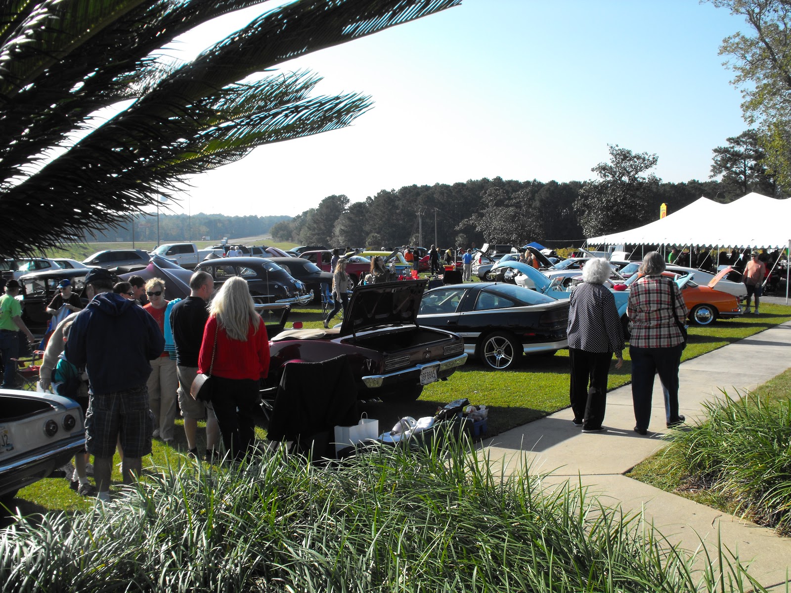 |
| So many show cars. |
Father didn't want to go for dinner, so Karen and I went to a little restaurant on the west edge of town called "Mom and Dad's" and had a good Italian dinner. We came back to the motel, got a decent night of sleep, and got up ready to go this morning (Sunday the 28th).
We modified the ACA route to stick almost completely on Highway 90. It cut off a couple of miles and was a good road, smooth pavement, good shoulders, and not too much traffic (but it was Sunday). Father was on the spot for our two breaks, and when we got to Chattahoochee, we loaded up the bikes to look for a motel. There was one terrible place on 90 just east of the center of town ( I don't remember the name, it is the only motel, a white building). The rooms were dark and stunk, and I could see the sky all around the wall mounted air conditioner. No discussion was needed, we took off for Tallahassee and got a room at the Comfort Inn on the extreme west end of town.
The ride today was nice, the only problems being the strong wind out of the north all day long, and the temperature. The temperature wasn't that bad, as it allowed us to keep cranking with overheating all day long. No photos, as it was very overcast and cloudy all day and there was nothing very photo-worthy.
The maps and numbers are as follows:
http://connect.garmin.com/activity/238146035#.UI3Sdbk3iK0.blogger
Friday, October 26, 2012
Day 34 (Pensacola to De Funiak Springs, FL)
We have finally reached our last rest day, after riding from Pensacola to De Funiak Springs. The day started with us getting a ride from our motel back to the ACA route, then we began pedaling about 8:30 after fighting rush hour traffic to get started. There was a strong headwind again, not quite as strong as yesterday, but unrelenting, straight out of the east all day long.
The first few miles of the route, highway 90 has very high traffic, moderate speed vehicles, and no shoulders. This was a disappointment because the best (only) photo opportunity was of I-10 heading east out of Pensacola. The interstate is an elevated bridge as it leaves the city, and it seems to disappear into the ocean. But, no photo op.
We continued on the way with several climbs, overall an elevation increase of over 200 feet. The high temperature today was over 95 degrees. With the headwind it was a difficult ride. I hit one of those points again where I hurt all over, felt sick, felt hot, and had a backache. It made for a tough day, but it was just a matter of pedal til you get where you're going.
There were a couple of other points of interest along the way. There were a couple of places with "wheelchair crossing" signs. These are a lot like the "elk crossing" signs or "deer crossing" signs in Arizona, but the road kill is a little gamier here. Florida also does something different with their garage sales. The sellers post all of their wares in the large grass shoulders along the highway. It is like traveling through a swap meet on the highway.
So no photos today, but the numbers and maps are on the link:
http://connect.garmin.com/activity/237303383#.UIsI5XvfDoc.blogger
Thursday, October 25, 2012
Day 33 (Dauphin Island to Pensacola)
I forgot to mention the couple that we saw a couple of days ago. We were riding from La Rue and were about 20 miles into the ride, when we saw two fully laden cyclists riding toward us. We stopped and talked to Kris and Gord McDonald, a couple from Canada who are riding the route from east to west. Kris rode west to east with the Adventure Cycling group 16 years ago, and was waiting for retirement to do it again. We exchanged a couple of stories and gave them our information so that we can get together when they make it through Phoenix.
Today was a regular 6AM start. We loaded the car and drove to the Dauphin Island Ferry where we were first in line. There were 7 vehicles on the small ferry and it ran us over to the east end of Mobile Bay in half an hour. There Karen and I got our bikes ready and headed in to Pensacola. That ride is so very flat and boring, except for some interesting flood proofing architecture, but today it was a fight because of the 15-20 MPH headwinds all day. We could barely hold 13 miles an hour riding into the wind. The Bridges made the ride interesting (check out the Garmin Connect link for ride data, the only elevation spikes are the bridges).
Father was supposed to meet us at the Florida border for our first break. He was parked about 31.5 miles in behind a "Police No Parking" sign. He said he had been down the road a couple of miles and there was no place to park. So we took our break and started rolling again. At 32 miles we passed from Alabama to Florida, and I got a flat tire at the "Welcome to Florida" sign. As I was changing the tire, on the side of the street in a souvenir shop parking lot, father went driving on past without even looking at us. So much for a support vehicle. He obviously lied about checking out the street and not seeing the Florida signs, about there not being any parking, and he doesn't pay attention when we are broke down on the side of the rode as he drives by. I am so tired of him saying, "I didn't see that", "I didn't know that" and on and on. He has left us hanging so many times, and when we do call his phone for help, he doesn't answer. He will say that he doesn't get the calls, but we show them to him on his missed calls log on his phone. If it wasn't so close to the end of the ride, I would adapt and change the plan again.
We finally caught up with father on Main Street in downtown Pensacola. The bikes were loaded up and we found a motel and dinner. Dinner was at McGuire's, an Irish pub and brewery. It's located at the corner of 9th Avenue and Gregory. Excellent food, good beer, and some of the best service ever. We then did our shopping for food and snacks for the next few days (should be the last five or six days) of riding.
Maps and numbers:
http://connect.garmin.com/activity/237105389#.UIoHv-AM8n8.blogger
Today was a regular 6AM start. We loaded the car and drove to the Dauphin Island Ferry where we were first in line. There were 7 vehicles on the small ferry and it ran us over to the east end of Mobile Bay in half an hour. There Karen and I got our bikes ready and headed in to Pensacola. That ride is so very flat and boring, except for some interesting flood proofing architecture, but today it was a fight because of the 15-20 MPH headwinds all day. We could barely hold 13 miles an hour riding into the wind. The Bridges made the ride interesting (check out the Garmin Connect link for ride data, the only elevation spikes are the bridges).
 |
| The Dauphin Island Ferry |
 |
| Today's Wind |
 |
| The Final State, we are in Florida |
Father was supposed to meet us at the Florida border for our first break. He was parked about 31.5 miles in behind a "Police No Parking" sign. He said he had been down the road a couple of miles and there was no place to park. So we took our break and started rolling again. At 32 miles we passed from Alabama to Florida, and I got a flat tire at the "Welcome to Florida" sign. As I was changing the tire, on the side of the street in a souvenir shop parking lot, father went driving on past without even looking at us. So much for a support vehicle. He obviously lied about checking out the street and not seeing the Florida signs, about there not being any parking, and he doesn't pay attention when we are broke down on the side of the rode as he drives by. I am so tired of him saying, "I didn't see that", "I didn't know that" and on and on. He has left us hanging so many times, and when we do call his phone for help, he doesn't answer. He will say that he doesn't get the calls, but we show them to him on his missed calls log on his phone. If it wasn't so close to the end of the ride, I would adapt and change the plan again.
We finally caught up with father on Main Street in downtown Pensacola. The bikes were loaded up and we found a motel and dinner. Dinner was at McGuire's, an Irish pub and brewery. It's located at the corner of 9th Avenue and Gregory. Excellent food, good beer, and some of the best service ever. We then did our shopping for food and snacks for the next few days (should be the last five or six days) of riding.
Maps and numbers:
http://connect.garmin.com/activity/237105389#.UIoHv-AM8n8.blogger
Wednesday, October 24, 2012
Day 32 (La Rue, MS to Dauphin Island, AL)
La Rue is not really a town. It is an intersection, a church on one corner and an unused building on another corner. We returned there after spending the night in Bayou La Batre, AL. and got started pedaling about 9AM. We had a nice ride today passing from Mississippi into Alabama.


The scenery and terrain remained very similar, but some of the construction features changed. We found some houseboats, which we haven't seen before, as well as some other unusual construction.
After we returned to Bayou La Batre, Karen agreed that she could probably finish another 20 miles. This would take us to the Dauphin Island Ferry over to the mainland on the east side of Mobile Bay. That way we can pack up in the morning, drive to the ferry, and once we are across we only have to ride about 55 miles before we reach Pensacola.
So today's info and details are rather routine and boring, except that Karen got a flat tire right after crossing over the bridge. We got it fixed, found the ferry, and returned to our previous nights' lodging to prepare for our final night in Alabama. 30 miles tomorrow and we are in the final state of Florida, rolling through Pensacola one day before Romney's speech there.
Map and numbers today:
http://connect.garmin.com/activity/236814694#.UIi5QrZQfRg.blogger


The scenery and terrain remained very similar, but some of the construction features changed. We found some houseboats, which we haven't seen before, as well as some other unusual construction.
 |
| Houseboats lining the river |
 |
| The first two story single wide I have seen |
After we returned to Bayou La Batre, Karen agreed that she could probably finish another 20 miles. This would take us to the Dauphin Island Ferry over to the mainland on the east side of Mobile Bay. That way we can pack up in the morning, drive to the ferry, and once we are across we only have to ride about 55 miles before we reach Pensacola.
 |
| Bridge to Dauphin Island |
Map and numbers today:
http://connect.garmin.com/activity/236814694#.UIi5QrZQfRg.blogger
Tuesday, October 23, 2012
Day 31 ( Bogalusa, LA, to La Rue, MS)
It was one stinky night, as the main industry in Bogalusa is the pulp (paper) mill. The aroma (read that as stench) from the mill permeates the whole town. Karen compared the smell to that of stale urine, while I thought it smelled more like a backed up sewer. Regardless of that, we were up on time this morning, and since the motel didn't have a continental breakfast, we ate pastries and fruit that we carry in the truck. We took the truck to the Wal Mart, and while I got the bikes ready to go, Karen went in and got ice for the coolers. Finally about 8AM we were off.
The road out of Bogalusa (route 10) is kind of rough, with a very limited shoulder. It was a little bit of a challenge, but once across the river and into Mississippi, the road changed to route 26 and was easier to travel. We deviated from the ACA route by staying on 26 from Bogalusa to Poplarville. It saved a few miles and was a relatively nice ride.

We road to Perkinston, where our first break was scheduled. On the way there I had another flat tire, after the 3 yesterday I changed it with no problems and we got on our way. I missed the turn onto "10 Mile Road" and we ended up with about 5 extra miles trying to retrace the route and find the right place. When we got there, father was waiting. Yeah! We got our snacks and I gave father the phone number for the only motel in Bayou La Batre, where we planned to spend the night. I asked him to call for rates and to make a reservation, as that is the only motel within 60 miles of the route in that area.
We then continued on the route, and as we got close to the Railroad Creek Bridge, we started seeing signs saying that the bridge was closed for repairs and to detour. Karen and I decided that however bad it was, we could walk across the partial bridge or wade across the creek, but we didn't want to detour. When we finally arrived at the bridge, it was obvious that it had been fully repaired and in use for some time, but the signs had not been removed. We continued to La Rue, where we stopped for the day and loaded the bikes on the truck for the shuttle to Bayou La Batre. As we started driving, I asked father if he had called and made a reservation. He said that he hadn't, that he thought we had done it. Right, we can call while we are riding 80 plus miles, with him sitting on his butt in the car. We were totally pissed off, but Karen called and got a reservation as we were driving the hour to town. What a crock!
Well, the motel is nice, Guest House Inn and Suites. We had dinner next door at the Chicken and Seafood take out restaurant, and it was actually really good.
So tomorrow we are planning to ride another 80 miles. This will put us within 30 miles of being one more day ahead of schedule. Karen and I plan to discuss it and see if we will make one more long day and get an extra day off, or just take one thirty mile day so we can have a lot of rest that day.
Today's map and numbers are at:
http://connect.garmin.com/activity/236564414#.UIdZEA9xIXc.blogger
The road out of Bogalusa (route 10) is kind of rough, with a very limited shoulder. It was a little bit of a challenge, but once across the river and into Mississippi, the road changed to route 26 and was easier to travel. We deviated from the ACA route by staying on 26 from Bogalusa to Poplarville. It saved a few miles and was a relatively nice ride.
 |
| Out of Louisiana |
 |
| And into Mississippi |
 |
| Nice Rolling Roads and lots of Forest on all sides |
 |
| Where do they put the rest of the body? |
 |
| Nice Gate entries at the horse ranches |

We road to Perkinston, where our first break was scheduled. On the way there I had another flat tire, after the 3 yesterday I changed it with no problems and we got on our way. I missed the turn onto "10 Mile Road" and we ended up with about 5 extra miles trying to retrace the route and find the right place. When we got there, father was waiting. Yeah! We got our snacks and I gave father the phone number for the only motel in Bayou La Batre, where we planned to spend the night. I asked him to call for rates and to make a reservation, as that is the only motel within 60 miles of the route in that area.
We then continued on the route, and as we got close to the Railroad Creek Bridge, we started seeing signs saying that the bridge was closed for repairs and to detour. Karen and I decided that however bad it was, we could walk across the partial bridge or wade across the creek, but we didn't want to detour. When we finally arrived at the bridge, it was obvious that it had been fully repaired and in use for some time, but the signs had not been removed. We continued to La Rue, where we stopped for the day and loaded the bikes on the truck for the shuttle to Bayou La Batre. As we started driving, I asked father if he had called and made a reservation. He said that he hadn't, that he thought we had done it. Right, we can call while we are riding 80 plus miles, with him sitting on his butt in the car. We were totally pissed off, but Karen called and got a reservation as we were driving the hour to town. What a crock!
Well, the motel is nice, Guest House Inn and Suites. We had dinner next door at the Chicken and Seafood take out restaurant, and it was actually really good.
So tomorrow we are planning to ride another 80 miles. This will put us within 30 miles of being one more day ahead of schedule. Karen and I plan to discuss it and see if we will make one more long day and get an extra day off, or just take one thirty mile day so we can have a lot of rest that day.
Today's map and numbers are at:
http://connect.garmin.com/activity/236564414#.UIdZEA9xIXc.blogger
Monday, October 22, 2012
Day 30 (Jackson to Bogalusa,LA)
This morning was the latest start ever, about 9:15 this morning. We slept in a few minutes late, then when we got ready to go, I noticed that Karen's bike had a flat rear tire. I took the time to patch her tube, then I patched the tube that I had changed out yesterday when my rear tire went flat. Once I had everything together, father drove us from St Francisville to Jackson, where we took of from the same parking lot (yea dollar general) where we ended yesterday.
While we were unloading the bikes I started talking to the guy standing next to our truck. His name is Darren Smith, and he works High Steel. He is currently contracted to build Cell towers, 200 ft off the ground. These cell towers out here are Very Tall. He pointed out the one he is currently working on and told us it was quite a bit of fun,but nothing like some of the 1,000 ft structures he has worked on. Cool Guy.
 We started out fine, everything going well, then about an hour into the ride we see father driving toward us going the wrong direction. He stopped and told us that there was no road where we were supposed to turn. I sat down with the map and figured out an alternate route that would only add about a mile to our scheduled mileage. We got started again and two miles down the road, Lo and Behold, there was the missing road. Karen and I turned down that road, and it was a real treat. A little narrow, but no traffic, and the trees arching over the road to make a shaded tunnel for us to ride through.
We continued and I missed the final turn to Tangipahoa, but we met a couple of guys at the convenience store where we were going to ask directions, and they put us back on track and only added a mile or two to our ride without backtracking. And it was actually a nice, smooth, scenic ride.
Then things got weird, like sometimes when I was working weird. As we pull into Tangipahoa, there is father parked in front of what looks to me to be a drug house. The first words ot of father's mouth were, " I think I found the county distribution center.". NO JOKE. When I asked why he parked there, he said that there weren't that many places in town to park. ( What that meant was that the crack house had the only tree that cast shade on the shoulder of the road.) We all three watched people come up to the house, make hand-to-hand exchanges, and leave as we were eating.We both grabbed a very quick bite, and as we did, father walked up to the runners on the porch of the house and asked to go to the bathroom. They told him to go around the side of the house, not allowing him inside. When he got back to the car, we told him to get in and go, that we would follow. Well, he finally got rolling a minute or two after we did. A couple of miles down the road we saw him pull on past one of the scheduled turns. We just turned down the proper road and kept going.
I had three flats (all rear tire) on today's ride. They seemed to take forever to change, and I was very tired (probably from riding on under inflated tires). We finally got into Bogalusa about sunset. I was running short on tubes and patches, so I went in Wal Mart and got a patch kit and a couple of tubes that I hope I can make work, as there are no bike shops anywhere near our route for the next couple of days.
101+ or 102+miles today, depending on which computer you believe. Numbers and map at :
http://connect.garmin.com/activity/236281296#.UIYcyrAOzVY.blogger
While we were unloading the bikes I started talking to the guy standing next to our truck. His name is Darren Smith, and he works High Steel. He is currently contracted to build Cell towers, 200 ft off the ground. These cell towers out here are Very Tall. He pointed out the one he is currently working on and told us it was quite a bit of fun,but nothing like some of the 1,000 ft structures he has worked on. Cool Guy.
 |
| Darren The High Iron worker (54 years old) |
 |
| Our Tree Lined Ride |

We continued and I missed the final turn to Tangipahoa, but we met a couple of guys at the convenience store where we were going to ask directions, and they put us back on track and only added a mile or two to our ride without backtracking. And it was actually a nice, smooth, scenic ride.
Then things got weird, like sometimes when I was working weird. As we pull into Tangipahoa, there is father parked in front of what looks to me to be a drug house. The first words ot of father's mouth were, " I think I found the county distribution center.". NO JOKE. When I asked why he parked there, he said that there weren't that many places in town to park. ( What that meant was that the crack house had the only tree that cast shade on the shoulder of the road.) We all three watched people come up to the house, make hand-to-hand exchanges, and leave as we were eating.We both grabbed a very quick bite, and as we did, father walked up to the runners on the porch of the house and asked to go to the bathroom. They told him to go around the side of the house, not allowing him inside. When he got back to the car, we told him to get in and go, that we would follow. Well, he finally got rolling a minute or two after we did. A couple of miles down the road we saw him pull on past one of the scheduled turns. We just turned down the proper road and kept going.
I had three flats (all rear tire) on today's ride. They seemed to take forever to change, and I was very tired (probably from riding on under inflated tires). We finally got into Bogalusa about sunset. I was running short on tubes and patches, so I went in Wal Mart and got a patch kit and a couple of tubes that I hope I can make work, as there are no bike shops anywhere near our route for the next couple of days.
101+ or 102+miles today, depending on which computer you believe. Numbers and map at :
http://connect.garmin.com/activity/236281296#.UIYcyrAOzVY.blogger
Sunday, October 21, 2012
Day 29 (Simmesport to Jackson, LA)
Shortly after we set out from that dump this morning, I reminded Karen that one month ago today, we started driving to San Diego to begin our adventure. It is hard to believe that we have been on the road for almost a month. There have been a lot of interesting times during that four weeks.
Within the first couple of miles, we got one of our two biggest climbs today. The first was the huge bridge over the Atchafalayah River, just east of Simmesport. It's a beautiful bridge and it has a great view of the flat countryside around it.
We kept pedaling along a route that I had cobbled together from the map last night. The Adventure Cycling map sends riders along mostly surface roads from Simmesport to New Roads, then due to the closure of one of the ferry's across the Mississippi River it sends them over a bridge and through a convoluted backtrack course to rejoin the route. With the luxury of a support vehicle, we used their posted detour, plus a little exploring along the well marked back roads, to get one town ahead on the route and save about 20 miles.
The bridge over the Mississippi was quite a sight. We rode over that, took a couple of photos, watched the tugs and barges and enjoyed the view. The view from both of the bridges today was great, the bridges being so high and the terrain so flat. Once we crossed the Mississippi, the terrain began to get a few little hills, more like the rolling terrain out near Lockhart, Texas, but with loads of vegetation. Several of the roads we were on today had tree covered canopies bridging the roadway, making it a very pleasant ride.

We saw one westbound tourer today, at the intersection of Louisiana 10 and 61, but he appeared to be in a hurry and didn't stop to talk. As we were riding through Jackson, we found a bike club booth set up in the park. When we stopped to check it out, we were told that they were sponsoring a Century and a Metric Century ride today through the area. Really interesting, fun, and informative about the area. Then when we were checking in at the Best Western, we learned that there had been a triathlon in St Francisville today. Very active area.
We rode all the way to Jackson today, but backtracked in the vehicle to stay in St. Francisville. They have a brand new Best Western there, and we figured that we could treat ourselves after last night.
Today's map and numbers at:
http://connect.garmin.com/activity/235857401#.UIRsUfZvgSk.blogger
Within the first couple of miles, we got one of our two biggest climbs today. The first was the huge bridge over the Atchafalayah River, just east of Simmesport. It's a beautiful bridge and it has a great view of the flat countryside around it.
 |
| The bridge over the Atchafalaya River |
We kept pedaling along a route that I had cobbled together from the map last night. The Adventure Cycling map sends riders along mostly surface roads from Simmesport to New Roads, then due to the closure of one of the ferry's across the Mississippi River it sends them over a bridge and through a convoluted backtrack course to rejoin the route. With the luxury of a support vehicle, we used their posted detour, plus a little exploring along the well marked back roads, to get one town ahead on the route and save about 20 miles.
The bridge over the Mississippi was quite a sight. We rode over that, took a couple of photos, watched the tugs and barges and enjoyed the view. The view from both of the bridges today was great, the bridges being so high and the terrain so flat. Once we crossed the Mississippi, the terrain began to get a few little hills, more like the rolling terrain out near Lockhart, Texas, but with loads of vegetation. Several of the roads we were on today had tree covered canopies bridging the roadway, making it a very pleasant ride.
 |
| The Mississippi River |

We saw one westbound tourer today, at the intersection of Louisiana 10 and 61, but he appeared to be in a hurry and didn't stop to talk. As we were riding through Jackson, we found a bike club booth set up in the park. When we stopped to check it out, we were told that they were sponsoring a Century and a Metric Century ride today through the area. Really interesting, fun, and informative about the area. Then when we were checking in at the Best Western, we learned that there had been a triathlon in St Francisville today. Very active area.
We rode all the way to Jackson today, but backtracked in the vehicle to stay in St. Francisville. They have a brand new Best Western there, and we figured that we could treat ourselves after last night.
Today's map and numbers at:
http://connect.garmin.com/activity/235857401#.UIRsUfZvgSk.blogger
Saturday, October 20, 2012
Day 28 (Oberlin to Simmesport, LA)
Last night was a terrible night's sleep, but I have a feeling it will be much better than tonight. We got up at 6Am and got ready to go, ate a quick breakfast and father ran us from DeRidder to Oberlin so that we could get started. Karen and I hit the road about 8:15 and rode the flattest 92 miles either of us has ever ridden. We both thought that the hump and crown of one of the crossroads was the biggest climb of the day. When we were about 25 miles in today, we saw another bicyclist heading westbound. As we slowed to say "Hi!" and share some road experiences, a pack of three or four dogs came charging and barking out of a driveway on our right. The other cyclist took off, as did we, and we never got a chance to talk to him. Somewhere around Cottonport we saw another traveller headed westbound. His name was John, and he said he has been on the road for 33 days, coming from either New York (Karen thinks) or Boston.
This was supposed to be an 83 mile day, but that would have put us in a campground only town, and we needed a motel, so we pushed on to Simmesport. That was not a good idea. The one motel in town (the Sportsmans Inn) has a reversible sign with Holiday Inn Express on the other side. (First warning bell?) We had to register in a convenience store, (second warning) and the room we were given had filthy towels and stained and dirty sheets (third warning). All of the rooms smelled of cigarette smoke, even though we requested a nonsmoking room. Karen went to the desk and got a different room, which at least had cleaner sheets. The housekeeper, a big black woman in her 40's, got in Karen's face for complaining about the room and linens. I guess she didn't realize what Karen has been doing for the past 4 weeks, and that Karen is not about to put up with anyone's garbage. She dressed down the housekeeper and sent her away.
The room is terrible, the shower is the worst we have seen, and the migrant Mexicans staying in the other rooms sound like they are ready to party all night. If we can get a little sleep, we will start as early as we can to get out of this dump. Then we will call Holiday Inn and report this place for their use of the Holiday Inn logos, signs, and room keys.
We were chased by dogs several times today, and we are finding that Karen's dollar store air horns are very handy for stopping the dogs. We don't have to worry about which way the wind is blowing, or about aiming them. We just yell "no" or "stop" at the dogs then hit the horns (which are mounted on our fanny packs) and the dogs stop chasing and go home.
It is now a couple of minutes before nine local time, and the first train of the evening just went by with it's horn blowing. It's gonna be a great night!
Map and numbers for today-
http://connect.garmin.com/activity/235395368#.UINYJfQmDsk.blogger
 | ||
| Beautiful home, note the double winding staircase framing the entry. |
Thursday, October 18, 2012
Day 27 (Kirbyville, TX to Oberlin, LA)
One day short of two weeks, that's how long it took us to ride across Texas. This morning at 9AM we crossed the Sabine River and the border of Louisiana. The ride was extremely flat today, I don't believe the Garmin,s reported -2 ft.elevation low, maybe closer to 20 ft. We passed a lot of tree farms and cattle ranches today, not many homes as spectacular as the Texas ranch homes. It is also surprising how many of the Texas properties have a large stonework entry at the fence, and Louisiana has gates, nothing fancy, just gates.
The breeze was nice today, about 5 to 10 mph and in our faces all day. We pushed all the way to Oberlin, although it has no motels or services. Then father brought us back to DeRidder where there is a nice motel (the Stagecoach Inn) which we will call home until Saturday morning. Then father will take us back to Oberlin and we will be on our way again.
We had heard from other cyclists the the road east out of Kirbyville was pretty nasty, with no shoulders and lots of logging truck traffic. While I have to say that those two assessments are accurate, the ride was not at all bad. The truckers gave us a lot of room, slowing for us and taking the other lane, waving, and generally courteous. While there was no shoulder, we rode just inside of the white line on good pavement with no problems. Rick and Dee's two wheel trailer might take up a little more space, but I don't see a real big deal. And that is only a short section about 17 miles along highway 363.
Tonight's dinner was at the Chinese Buffet. The restaurant is located about a mile north of 190 on 171, as are many restaurants and Skipper's motel (highly recommended by Jeff Skinner, our most recent westbound traveler). Dinner was $34 for 3 people, not bad for all you can eat .
So now there is a rest day for laundry, shopping, and resting our tired and sore rear ends. A couple of photos today.
The numbers for today's ride and the map at the following link:
http://connect.garmin.com/activity/234745527#.UIBvn9pjaas.blogger
The breeze was nice today, about 5 to 10 mph and in our faces all day. We pushed all the way to Oberlin, although it has no motels or services. Then father brought us back to DeRidder where there is a nice motel (the Stagecoach Inn) which we will call home until Saturday morning. Then father will take us back to Oberlin and we will be on our way again.
We had heard from other cyclists the the road east out of Kirbyville was pretty nasty, with no shoulders and lots of logging truck traffic. While I have to say that those two assessments are accurate, the ride was not at all bad. The truckers gave us a lot of room, slowing for us and taking the other lane, waving, and generally courteous. While there was no shoulder, we rode just inside of the white line on good pavement with no problems. Rick and Dee's two wheel trailer might take up a little more space, but I don't see a real big deal. And that is only a short section about 17 miles along highway 363.
Tonight's dinner was at the Chinese Buffet. The restaurant is located about a mile north of 190 on 171, as are many restaurants and Skipper's motel (highly recommended by Jeff Skinner, our most recent westbound traveler). Dinner was $34 for 3 people, not bad for all you can eat .
So now there is a rest day for laundry, shopping, and resting our tired and sore rear ends. A couple of photos today.
 |
| Karen Entering Louisiana |
 |
| This is the farthest I have ever been East |
 |
| Nice to know which way to go if the BIG ONE comes |
 |
| Our 7:30 start out of Kirbyville |
The numbers for today's ride and the map at the following link:
http://connect.garmin.com/activity/234745527#.UIBvn9pjaas.blogger
Subscribe to:
Comments (Atom)